A friend recently pointed me toward a great resource, the Maryland Supply Tax of 1783. The Continental Congress periodically levied a tax on each state to pay for soldiers’ salaries and supplies during the Revolutionary War. Many of the Maryland records of the 1783 tax survive and are preserved in the Maryland State Archives (MSA). Best of all, the records are available online so you can review them from home.
MSA published an index of the records for some counties at: http://msa.maryland.gov/msa/stagser/s1400/s1437/html/ssi1437e.html
Most importantly, the Maryland Society of the Sons of the American Revolution (MDSSAR) scanned the surviving records and posted them on their website at: https://www.mdssar.org/membership/marylandtaxlists
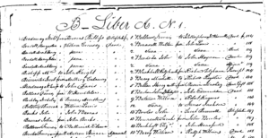
Like most tax records of the era, these contain a wealth of information about the property owners. The records list all heads of household along with details such as land holdings, names of the tracts, numbers of slaves by age and gender, numbers of horses and cattle, the value of each asset and the total tax assessed. Some jurisdictions also describe the real property as to location, condition of the soil, and improvements. Additionally, the lists show the number of white inhabitants for each household, sometimes divided by gender. Males without taxable property between the ages of 18 and 50 were listed and assessed a default tax of 15 shillings. Paupers were listed as such and assessed no tax.
I recommend beginning at the searchable MSA index to identify the pages and tax district where a person of interest or a named tract of land is listed. Then logon to the MDSSAR site and scroll to the proper location. The scanned records are alphabetical within each tax district, making the site easy to use. I was pleased to find my family, the descendants of John Willis, listed here.[1]
The John Willis Family
In 1702, the John Willis who settled in Dorchester County patented 50 acres of land named Wantage located on the Little Blackwater River about three or four miles from Cambridge. John had four sons: John Jr., Thomas, Andrew, and William. We know from county land records the following information:
John, Jr. bought land in 1717 on Marshy Creek in what would become Caroline County. John’s land became known as Willis’s Regulation and stayed in the family for several generations.
Thomas purchased land on Marshy Creek adjoining John’s tract. However, he died without issue.
Andrew ultimately lived in Dorchester County on his second wife’s inherited land located west of the main Blackwater River. He expanded his holdings with a patent called New Town in 1730.
William inherited Wantage from his father John, Sr. in 1712 and lived there until 1734 when he sold to William Soward, one of his wife’s brothers.
Sons John, Jr. and Andrew, Sr. had proven children. Son William had one likely son Thomas, who does not appear in the records. The Caroline County assessment lists the following sons of John, Jr.: Joshua, John III, and Jarvis; and his grandsons Henry, Andrew, Richard, Thomas, Joshua, and Robert. The Dorchester County assessment lists three grandsons of Andrew, Jr.: Andrew, John, and Jarvis.[2] That list also shows William Soward as the owner of Wantage, the Willis family’s original tract, and Levin Hughes as the owner of New Town, previously owned by Andrew’s family. Let’s turn to the detail within each county’s assessment.
Caroline County Assessment
The 1783 assessment divided Caroline County into three districts – Upper Choptank, River, and Lower Choptank Districts.[3] All the sons and grandsons of John Willis, Jr. listed on the 1783 rolls are in Lower Choptank. There are other Willis families in the county not related to the John Willis of Marshy Creek. Those Willis groups can be identified and distinguished generally by their lands.[4] Here is what the record reveals about each Willis related to John, Jr., grouped by family:
Isaac Willis, son of John, Jr., was alive until 1789 when Letters of Administration issued on his estate. However, he is not listed in the 1783 tax assessment. We can conclude he did not own land and was too old to be otherwise listed. Therefore, he was exempt from taxation. Neither of his sons owned land either.
Henry Willis, listed as “of Isaac” in the 1778 Loyalty Oath records, is shown in the tax assessment. He does not own land and heads a household consisting of one male and two females. His property including 3 horses and 3 cattle are valued at £30.
Andrew Willis, listed as “of Ic” in the 1783 tax assessment, is shown with no land and a family of one male and three females. His personal property is assessed at £10.
Apparently, these Willis men worked land owned by others, possibly relatives. As seen below, many in the family owned significant acreage.
Richard Willis, son of John, Jr., died in 1764. His four sons listed below owned 1,000 acres of land and total property valued at £727.
Richard Willis, son of Richard, Sr., owned 200 acres called Sarah’s Delight, Addition to Sarah’s Delight and Newfound Land. Only 20 acres was cleared while the rest was forested. Richard lived alone in 1783, however he had a female slave age 14-36 and two older slaves. He did not marry until five years later. His property was assessed at £185.
Thomas Willis, son of Richard, Sr., owned 400 acres being part of Perry’s Delight and part of New Land, 100 acres of which was under cultivation. He owned one slave and 5 cattle. His household apparently consisted of just him and his wife (known from other sources to be Elizabeth Perry). Thomas was one of the more prosperous young men in the region with property valued at £260.
Joshua Willis, Jr., son of Richard, Sr., owned 200 acres named Good Luck and part of New Land adjoining his brother Thomas. The improvements on his land were noted as “Bad,” presumably in need of repair. He owned one slave and 22 cattle with a total property value of £190. He headed a household of two males and four females.
Robert Willis, son of Richard, Sr., owned 200 acres of land, which was part of Perry’s Discovery. The improvements on his land were also noted at “Bad.” His household consisted of three males and three females. Robert’s property was valued at £92.
Joshua Willis, son of John, Jr., owned 464 acres called Painters Range, Bank of Pleasure and Willis’s Luck. Acreage under cultivation totaled 180 acres and property improvements were listed as “Good.” Joshua owned ten slaves, three of them males ages 14-45. He also had seven white males in his household, which explains his ability to farm so much acreage. He had 23 cattle and nine horses. His property assessed at £676, clearly the wealthiest individual Willis on the list. His total household was seven males and five females.
John Willis III, son of John, Jr. and his second wife Elizabeth Sharp, owned 163 acres called Addition to Willis’s Regulation. This land combined the original tract on Marshy Creek purchased by John Willis, Jr. with other patents and resurveys. John III inherited the land under his father’s 1764 will after the death of his mother Elizabeth. Improvements on the land were in Bad condition, but 100 acres were under cultivation. John had four slaves, five horses and 11 cattle, and headed a household of seven males and two females. His property value totaled £192.
Jarvis Willis, son of John, Jr. and his second wife Elizabeth Sharp, did not own land. He headed a household of one male and three females and had property assessed at £10.
The Willis families descended from John, Jr. owned 1,627 acres and total property valued at £2,105 – quite impressive for a group that began from the humble beginnings of John Willis of Wantage. Sadly, the record also shows that among their “property” were nineteen human beings. Their aggregate white households totaled 24 males and 23 females.[5]
Dorchester County Assessment
The Willis families in Dorchester related to John Willis of Wantage were descended from John’s son Andrew. This branch of the family was not as successful in the state of Maryland as the John Jr. branch. Many of them migrated to the mainland, seeking improved fortune in Virginia, North Carolina and other places. The descendants who remained did not have significant property. The Willises or the lands related to the Willises are scattered among Dorchester County’s three districts – Upper, Middle, and Lower.[6]
Andrew Willis, Jr., son of Andrew, Sr., is not listed because he died in 1778.
Andrew Willis, son of Andrew, Jr., owned 60 acres called Fisher’s Venture located near Staplefort’s Creek in the Lower District. Cleared acreage amounted to 8 acres. Andrew had eight cattle and a total property value of £71. His household included seven people total. Dorchester County records do not indicate gender of the white household members.
Richard Willis, son of Andrew, Sr., is not listed because he died in 1773. He had inherited in 1738 half of land called New Town from his father. Richard willed his half of New Town to his daughter Mary, wife of Benjamin Meekins. Richard willed other land he owned called Buttons Chance to his daughter Elizabeth.
After her husband died, Mary Willis Meekins, daughter of Richard, sold her share of New Town to Levin Hughes in 1782. Therefore, she is not listed.
Elizabeth Willis, daughter of Richard who inherited Buttons Chance, is not listed as its owner. Instead, a Budd Shinton is shown as the owner of 27 acres called Buttons Chance in 1783. I found no purchase of Buttons Chance by Shinton. It is possible that he married Elizabeth Willis. He owned two other tracts: 54 acres being part of Johns Delight plus 93 ½ acres unnamed.
John Willis, son of Richard, is listed as a pauper with no assets yet a household of eight people. There are three Johns who could be this pauper. One is John, mentioned below, who inherited and sold part of New Town. He was not likely to be without assets in 1783. John who inherited New Town also had a son John, but he was too young to have a household of eight people. Therefore, I eliminated both of these men leaving the listed pauper as John, son of Richard.
John Willis, son of Andrew, Sr., is not listed. He inherited the other half of New Town from his father through the demise of his brother George. Andrew’s 1738 will gave New Town to sons Richard and George with their share to fall to son John should either die without issue. George apparently died without children because John sold half of New Town to Levin Hughes at some time before the 1783 assessment. That sale was recorded in 1784. I surmise that John had moved away before 1783. Levin Hughes is therefore listed as the owner of 85 acres called Addition to New Town in the Lower District of Dorchester.
Jarvis Willis, son of John, is listed in the Upper District without any land. He has two horses and five cattle and total property valued at £23. He headed a household of eight people.
The last land of interest to the Willis family is the original 50-acre tract called Wantage. John of Wantage willed it to his son William. William and his wife Judith sold it in 1734 to William Soward, one of her brothers. The 1783 tax list shows William Soward as owning 50 acres being part of Bridge North and 50 acres called Wanton [sic Wantage] both in the Middle District of Dorchester. Improvements on the property included an old frame dwelling, two logged houses and an orchard.
One possible disparity in the record is that the lands are stated as situated on the Little Choptank. That is certainly true of Bridge North, which is located in the neck region of Dorchester on Hudson’s Creek. However, Wantage is located near the Great Choptank River which might be in the Upper District. The custom of the day was that property owners rendered their own property, sending a notice to the tax assessors of the tally of acreage and other taxable property. William Soward likely lived in the Middle District on Bridge North, property long held by his family. I suspect as a matter of convenience, Soward rendered both properties to the Middle District commissioners rather than making separate submissions to the Middle and Upper District. In any event, I am confident the property in question was the original Wantage.
I highly recommend everyone take a look at the data available in these records. They help form a better picture of the life and circumstances of folks who lived so long ago.
*************
[1]Note: The Willis surnames in Caroline County appeared in the MSA Index but were missing on the MDSSAR site. However, knowing where they should be from the index, I requested and got copies of those pages from the Maryland Archives.
[2] See separate Appendix to The John Willis Family and The Maryland Supply Tax of 1783 for an abbreviated descendant chart for John Willis of Wantage highlighting the names of people mentioned here and related land.
[3] Caroline County’s normal jurisdictional subdivisions or “Hundreds” were Great Choptank, Fork, Tuckahoe, Bridgetown and Choptank. The 1783 tax districts were as follows: 1) Lower Choptank District – made up of Great Choptank Hundred and Fork Hundred. This district encompassed the entire southern part of the county bordering Dorchester and bounded on the east by the Choptank River and on the west by Delaware; 2) River District – parts of Tuckahoe and Bridgetown Hundreds; and 3) Upper Choptank District – the remainder of Tuckahoe and Bridgetown Hundreds and all of Choptank hundred.
[4] The Willis data are found on pages 57-59 of Lower Choptank District, Caroline County.
[5] Other Willis listings in Caroline County include two families descended from Quakers Richard and Frances Willis. Elijah, Thomas and William are clustered around land called Timber Tree Neck. The second group includes Andrew. Joseph, Ezekiel and Thomas associated with land called Friendship Regulation. Needless to say, none of these families owned slaves.
[6] The Upper District included Great Choptank Hundred and Nanticoke Hundred, which bordered Caroline County and Delaware, respectively. I do not know the western or southern boundary. The Middle District covered Transquakin and Little Choptank Hundreds. The Lower District was everything south of Transquakin and Little Choptank.